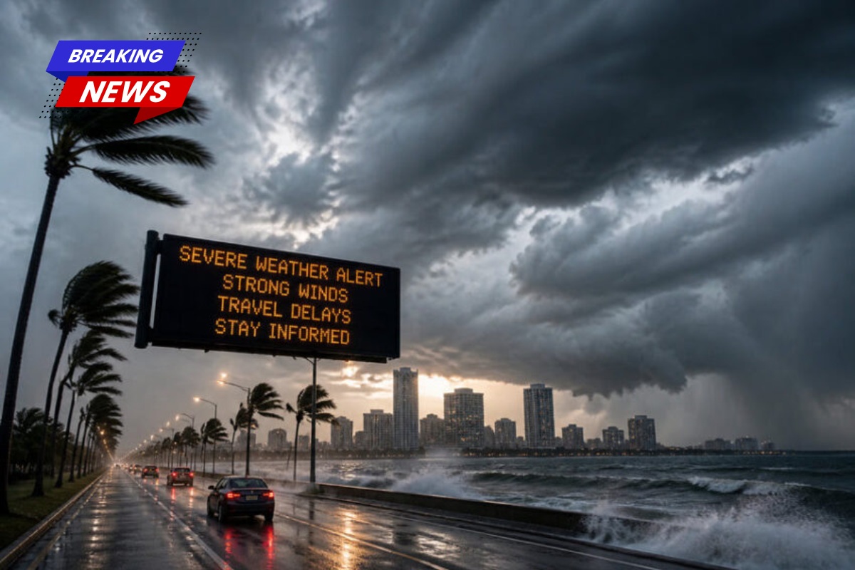
Residents along the Gulf Coast are being urged to stay weather-aware as forecasters have issued a First Alert Day for Tuesday due to the threat of strong to potentially severe thunderstorms.
Weather conditions are expected to become more active during the late afternoon and evening hours, with damaging winds, heavy rainfall, and intense lightning posing the greatest risks. Forecasters are also monitoring a developing weather system in the Gulf that could bring additional impacts later this week and into the weekend.
First Alert Day Issued for Strong Storm Threat
Meteorologists have declared a First Alert Day for Tuesday as atmospheric conditions become favourable for the development of strong thunderstorms.
The increased risk is linked to a frontal boundary moving south toward the Gulf Coast. During the summer months, storms that form along these weather fronts often become more intense due to the combination of heat, humidity, and unstable air.
As a result, weather experts are warning that some storms could become severe during the late afternoon and evening hours.
Residents are encouraged to monitor forecasts closely and be prepared for rapidly changing weather conditions.
Damaging Winds and Heavy Rainfall Possible
The primary concerns with today’s storms include strong wind gusts, periods of heavy rainfall, and frequent lightning.
Strong winds can bring down tree branches, damage outdoor structures, and create hazardous driving conditions. Heavy rainfall may also lead to temporary street flooding, particularly in areas with poor drainage.
Lightning remains one of the most dangerous aspects of summer storms and can strike several miles away from a thunderstorm.
Forecasters are advising people to move indoors immediately if thunder is heard.
Storm Chances Continue Into Wednesday
Although the strongest weather is expected on Tuesday, unsettled conditions are likely to continue into Wednesday.
Scattered showers and thunderstorms may persist as moisture remains across the region behind the frontal boundary.
While widespread severe weather is not currently expected on Wednesday, periods of rain and thunderstorms could still affect outdoor activities and travel plans.
Residents should continue monitoring weather updates throughout the middle of the week.
Temporary Drying Trend Expected Thursday
Following several days of storm activity, weather conditions are expected to improve briefly on Thursday.
Forecasters predict a short-term drying trend as rain chances decrease and more stable weather moves into the area.
This break in rainfall may provide temporary relief before another weather system begins affecting the Gulf Coast later in the week.
However, the quieter weather is not expected to last long.
Gulf Disturbance Being Closely Monitored
Attention is already turning toward a developing disturbance in the Gulf that could influence weather conditions from Friday through the weekend.
Meteorologists expect a low-pressure system to form offshore and gradually strengthen enough to produce widespread rain and gusty winds across coastal areas.
Although significant tropical development is not currently anticipated, the system is expected to generate several impacts commonly associated with tropical weather.
Forecasters will continue tracking the disturbance as new data becomes available.
Heavy Rain and Gusty Winds Expected This Weekend
The developing Gulf system could bring periods of heavy rainfall beginning Friday and continuing into the weekend.
In addition to rain, gusty winds may affect coastal communities and create rough marine conditions.
The combination of persistent onshore winds and increased moisture could lead to reduced visibility, hazardous travel conditions, and localised flooding in some areas.
Residents living in flood-prone locations should remain aware of future forecasts and any potential weather advisories.
Elevated Tides and Water Levels Possible
One of the biggest concerns associated with the Gulf disturbance is the potential for higher-than-normal tides.
Forecasters predict that water levels along the coast could rise between one and three feet above normal by the weekend.
These elevated water levels may increase the risk of minor coastal flooding, especially during periods of high tide.
Boaters, anglers, and coastal residents are advised to stay informed as conditions develop.
Tropical Development Not Expected
At this time, meteorologists do not expect the Gulf disturbance to strengthen into a significant tropical storm or hurricane.
However, weather experts stress that even weak tropical systems can produce dangerous impacts, including flooding rainfall, gusty winds, and elevated surf conditions.
For that reason, the system will continue to be monitored closely throughout the week.
Any changes in development potential or forecast impacts will be communicated through future weather updates.