After a calm start to May, the central United States saw a dramatic change this weekend with tornadoes, massive hail, and strong winds. The storms are expected to peak on Monday, making this one of the most dangerous periods of severe weather in the Plains and Midwest this spring.
Severe Storms Poised to Hit Hard
Monday could bring the strongest round of storms yet. Meteorologists warn that the region might see powerful tornadoes, some rated EF3 or stronger, along with destructive hail, damaging winds, and heavy rain. These storms are typical of May in the Plains and Midwest, which often experience the season’s most intense weather during this month.
The month began quietly due to a jet stream pattern that limited storm formation. Now, that pattern is shifting, allowing dangerous storms to develop across the heartland.
Sunday’s Destructive Storms
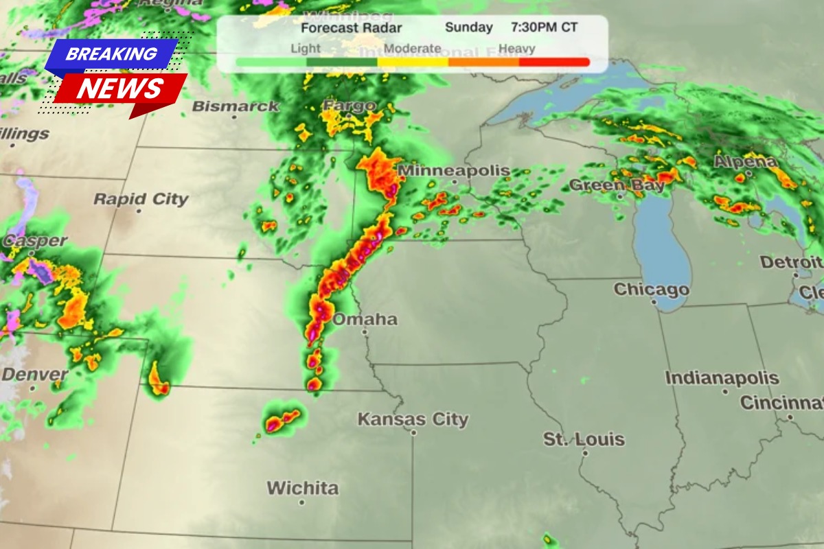
Storms quickly formed on Sunday afternoon across Kansas, Nebraska, Iowa, and southern Minnesota. Hail larger than baseballs fell, and several tornadoes touched down. The Storm Prediction Center had issued a level 3 of 5 risk for severe storms across much of this area.
More than a dozen tornadoes were reported, along with over 100 hail reports and 150 reports of damaging winds. In St. Libory, north of Grand Island, Nebraska, a strong tornado damaged multiple homes. Videos showed people and a dog being rescued from the basement of a collapsed house.
A tornado emergency — the most serious tornado warning — was issued near Hebron, Nebraska. One home was destroyed, but no injuries were reported. By late Sunday night, the storms formed a squall line, making damaging winds the main threat. Wind gusts could reach 75 mph, with the possibility of a few short-lived tornadoes along the line.
Forecast for Monday and Tuesday
The biggest wave of storms is expected Monday as strong jet stream energy meets high moisture levels. The Storm Prediction Center issued a rare Level 4 of 5 risk for eastern Kansas and Nebraska. Afternoon supercells could produce large tornadoes and huge hail.
The highest tornado risk is from central and eastern Kansas to southeastern Nebraska and northwestern Missouri. By evening, damaging winds will become the main concern, though tornadoes could still occur overnight. How storms behave in the morning may affect which areas see the strongest tornadoes in the afternoon.
On Tuesday, thunderstorms will continue in the morning, with a Level 2 of 5 risk stretching from northern Texas to Michigan. The tornado threat will drop as the cold front becomes the main trigger, but strong winds and hail will remain concerns.
Wildfire Danger in the Southwest
The same weather system causing tornadoes in the Plains is creating extreme fire conditions in the Southern High Plains. A Level 3 of 3, extremely critical fire threat remains in southwestern Kansas, the Texas Panhandle, and northeastern New Mexico. A wider area in New Mexico faces a Level 2 of 3, critical risk.
Dry fuels, low humidity under 10%, and strong winds of 25–30 mph (gusting up to 50 mph) can make fires spread rapidly. The National Weather Service warns that any fire could grow dangerously fast, posing a life-threatening risk.